|
 |
This site uses cookies - see our privacy policy. Ads & links in bold may give us a small payment from the seller, at no cost to the buyer. However, this never affects our views - if we like it, we recommend it.
10 Best Isle of Wight Walks (Circular, 3-9 miles) 2024 Guide
There are dozens of good Isle of Wight walks, but we've attempted to pick out the 10 best Isle of Wight walks for adults. Several of them are National Trust suggested routes with a few others from elsewhere.
All of these have the following criteria:
More ambitious walkers might prefer to do the entire Isle of Wight coastal path over several days. Realistic parents might like our guide to family friendly walks of about 1 mile.
One thing worth mentioning is that coastal footpaths tend to be closed from time to time. This is usually because there has been a landslip. As a result, you'll end up doing a big detour through an industrial estate. The current list of closures is available on the Isle of Wight Council website.
All of these have the following criteria:
- they include at least a bit of the Isle of Wight Coastal Path. If you can't see the sea on an Isle of Wight walk then you needn’t have paid for the ferry.
- they are circular walks. No one wants to be walking back where they came from or catching a bus to the start.
- they are all 3-9 miles long.
More ambitious walkers might prefer to do the entire Isle of Wight coastal path over several days. Realistic parents might like our guide to family friendly walks of about 1 mile.
One thing worth mentioning is that coastal footpaths tend to be closed from time to time. This is usually because there has been a landslip. As a result, you'll end up doing a big detour through an industrial estate. The current list of closures is available on the Isle of Wight Council website.
1. Freshwater Bay to The Needles, West Wight (8 miles)
The West Wight is probably my favourite bit of the Isle of Wight. This walking route from Visit Isle of Wight covers a big chunk of it including Freshwater Bay, which is usually in my top five Isle of Wight beaches. If you do the full thing, it also includes Headon Warren which is my mother's favourite Isle of Wight walk.
It’s quite a hilly walk but it has terrific coastal views of nothingness. Places to stop include the café at The Needles or the café within the National Trust's Old Battery. The latter requires National Trust membership to access but it has great views. If you want a panini and a latte before or after the walk, I would go for the café at Dimbola or the Piano Café in Freshwater Bay.
The Visit Isle of Wight route says it is six miles but it's actually more like eight miles. I checked with my friend Eminem, who agreed that it was was definitely eight miles (Ed: please could we have less references to 20 year old films?).
You can cut out the bit around Headon Warren if you want to shorten it but it does look very photogenic with its purple heather (at its peak in August).
We did this walk on an early morning in August - read the blog.
Shorter version: You can get a good feel for this part of the West Wight by walking up to the Tennyson Monument from Freshwater Bay and back down the hill. It's not circular, but it's just under three miles in total. Alternatively, there's a popular four mile walk around Headon Warren which offers views of the Needles and Hurst Castle. Both walks are the sort which end with people saying "well, that blew away the cobwebs".
Longer version: There’s a longer version from the Saturday Walkers Club that will appeal to anyone who owns a pair of hiking boots and one of those transparent map holders. It is 12 miles and also goes via Totland and Yarmouth.
Totland and Colwell are both nice beaches which are along the route. Yarmouth is a good point for lunch and it has a fairly hidden beach called Sandhard.
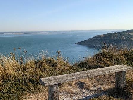
Start at Freshwater Bay, which has glistening seas on a good day
|
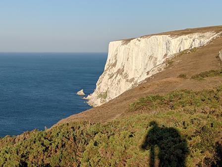
The route to the Needles hugs the coastline closely
|
Overlooking Alum Bay - probably the most famous beach on the Isle of Wight
|
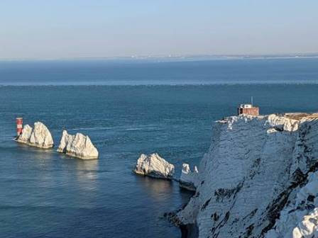
If you can make it to the Needles New Battery, you'll be rewarded with this view
|
2. West Wight Beaches and Hills (7.5 miles)
This walk from the National Trust covers one of the least developed areas of the Isle of Wight. A chunk of it involves walking by the beach in an area famed for dinosaur bone discoveries. Don’t get your hopes up though, they mostly look like stones...
We spent most of our youth at the beach at Compton Bay, which is shown off in all its glory along this route. You can even see the spot where I proposed to Mrs Guru (near to the Hanover car park, look for the blue plaque).
It’s quite hilly and includes Afton Down, near where the Isle of Wight Festival 1970 hosted Jimi Hendrix and a vast crowd. It caused such uproar that the local council banned large gatherings for more than 30 years afterwards.
It also goes near to JB Priestley’s former home in Brook, which is now split into private apartments.
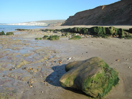
This walk includes a number of West Wight beaches...
|
...which are famous for dinosaur discoveries and unspoilt views
|
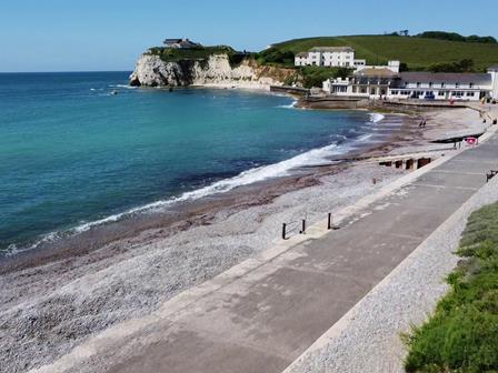
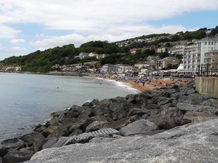
3. Ventnor, Luccombe and Shanklin, South East Wight (8.5 miles)
This walk from AllTrails starts and finishes in Ventnor, which is an old fashioned seaside resort with a few places to eat. AllTrails will let you see the route on the screen, but you have to pay for a printed version.
The first quarter goes along the seawall to Bonchurch. This section is a favourite of ours over the years as you get waves crashing against the wall. This section has seen some closures, so check the Isle of Wight Council footpaths page first.
It then heads towards Shanklin, which is a slightly busier resort. Again, you’ll be able to find something to eat there.
Their suggested route doesn’t actually incorporate the esplanade in Shanklin. I would say it’s worth a quick detour if your legs can manage it. There are a couple of seafront restaurants in a row, which will give you a great view with your sandwich. Otherwise, get yourself something to eat on Ventnor's seafront.
Shorter version: the National Trust has a 5 mile walk which focuses on the Luccombe part of the walk.
We like the coastal path at Bonchurch on a sunny day
|
Ventnor is a quirky little seaside town
|
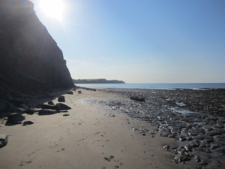
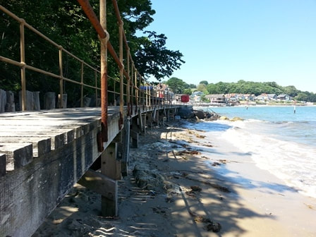
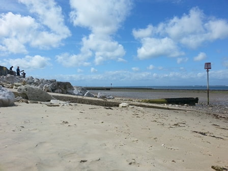
4. St Helen's and Priory Bay, East Wight (4 miles)
This walk is best done at low tide, otherwise there's a detour which is much less pretty. The longer route includes Priory Bay, which is a fantastic sandy beach. If it wasn't so much effort to reach, it would probably be the most popular beach on the Isle of Wight.
You also wander along the St Helen's Duver which was once a golf course but is now National Trust land. It's another one with directions provided by the National Trust. They include advice on timings around tides.
You also wander along the St Helen's Duver which was once a golf course but is now National Trust land. It's another one with directions provided by the National Trust. They include advice on timings around tides.
Priory Bay is a super sandy beach...but you'll need a low tide to do this walk properly
|
This walkway can be found near Priory Bay
|
Priory Bay and Seagrove Bay on a grey day
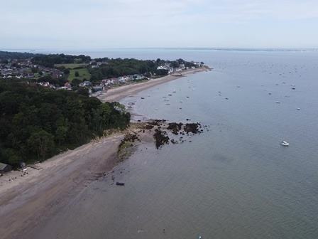
5. Bembridge and Culver Down, East Wight (6.5 miles)
This is another National Trust walk, which is one of the better routes around the East Wight. It's not as coastal as some walks, but it passes a few landmarks including Bembridge Windmill, the RSPB's Brading Marshes and Bembridge Down. On Bembridge Down/Culver Down, you'll find the remains of Bembridge Fort and terrific views towards Sandown and Shanklin. There's also a pub called the Culver Haven Inn which a lot of walkers visit. Bembridge Fort is inaccessible most of the time but the National Trust organise occasional tours.
The coastal section goes along Whitecliff Bay. It's one of my favourite Isle of Wight beaches but it's also hard to access by car so it tends to be quiet. At the right time of year there's at least one place to buy food and drink on the beach.
Shorter options: The first option is a National Trust walk of 2.8 miles called Circumnavigate Culver trail. It starts at Bembridge Fort, heads in the direction of Yaverland and then continues towards Whitecliff Bay. It's a nice stretch of the coastal path although you might need to hold onto your hat as it is windy up there.
The Culver Down cliffs are home to ultra-rare White-Tailed Eagles which were released there in 2019 - more than 200 years after they disappeared from the south coast (read more in our guide to things you probably haven't seen on the Isle of Wight).
Another option is this walk from Visit Bembridge called the Culver Trail. It is 3.75 miles and includes Bembridge Windmill. The windmill is a nice way to spend an hour as long as you don't mind climbing steep ladders.
Finally, there's a walk which just circles round Bembridge and has the big advantage of spending a long time hugging the coastline. It's just over 4 miles.
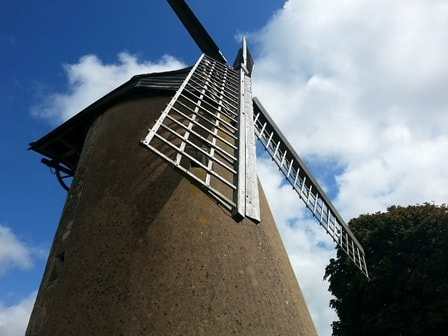
There's a sail on at Bembridge Windmill
|
Whitecliff Bay is on the route of this East Wight walk
|
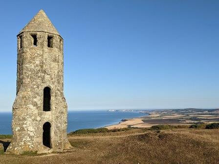
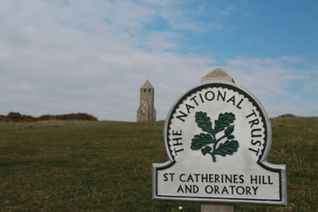
6. The Pepperpot (4.5 miles)
This guide to the Isle of Wight's best walks is now heading to the South Wight for a triple bill of walks around The Pepperpot, St Catherine's Lighthouse and St. Lawrence. I guarantee this isn't one of those Matrix-esque trilogies which gets gradually worse with each film.
I love the dramatic scenery of the South Wight, which is very isolated in places. The rocky bays around the South Wight coast don't feel that they could possibly be on the same Island as TK Maxx in Newport.
A short version of this walk to the Pepperpot is an easy one with young children. You get 360 degree views and it only takes half an hour, However, this longer route covers the hilly area which is slightly further inland as well. A similar alternative walk is offered by HF Holidays on Viewranger. Their route also includes the Pepperpot but it goes a bit closer to the coast and is 5 miles.
In case you're wondering, the Pepperpot is also known as St Catherine's Oratory. The story goes that the Pope told a landowner to build a lighthouse as penance after he helped himself to shipwrecked communion wine. Most of the building disappeared but the tower remained.
I've often wondered why it's quite so far inland considering that it's a lighthouse. St Catherine's Lighthouse was built in a more coastal location several hundred years later.
There are a couple of good circular walks based around The Pepperpot
|
It's a little bit of a climb but you get views across the Isle of Wight
|
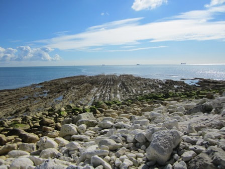
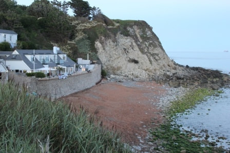
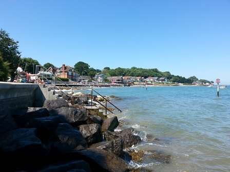
7. Ventnor to St Lawrence, South Wight (5 miles)
This is a good South Wight walk for anyone who wants to see a big chunk of the coastal path.
There are a few similar versions online. This 5 mile route from Lin's Isle of Wight Walking Blog includes a lot of photos, which is useful for not getting lost. A similar route is offered by a website called Outdoor Active. Their version includes a clickable map which makes planning your route a bit easier.
It starts from Ventnor and includes Steephill Cove, which is a favourite of a lot of locals (and visitors). It also includes several lesser-known beaches such as Orchard Bay, which was notorious for its part in a drug smuggling operation about 20 years ago.
The coastal path along this part of the Isle of Wight is quite dangerous and narrow in places. On the plus side, you can access remote beaches which are often empty on a summer's day in August.
Longer version: If you laugh at the thought of a 5 mile walk then you might prefer a 12 mile walk that includes the same route but also includes a big chunk of Niton and Blackgang. It's a hilly area with good views.
Orchard Bay is one of several quiet beaches on the walk
|
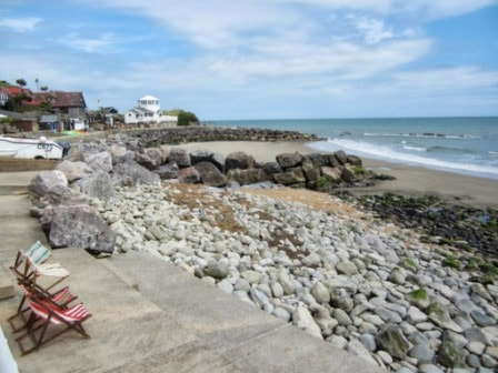
Steephill Cove has a cafe and is popular in summer
|
8. St Catherine's Lighthouse, South wight (3.5 miles)
The final chapter in our South Wight trilogy is a hilly and wiggly walk around St Catherine's Lighthouse. A few years ago, you could incorporate a tour of the lighthouse but that isn't available anymore. If you're as cool as me, then you will already know that this was the location for the music video 'Angelica' by Wet Leg.
As well as the views from the highpoints you also get to visit a couple of isolated and quiet beaches. I've got a soft spot for Castlehaven.
There's also some local history around Marconi who was a pioneer in communications. Early experiments were carried out around this part of the Isle of Wight.
The Buddle Inn is a big and busy pub in the area or there was an excellent posh café at Castlehaven last time we visited.
Castlehaven Beach is a lesser-visited beach with a lot of charm
|
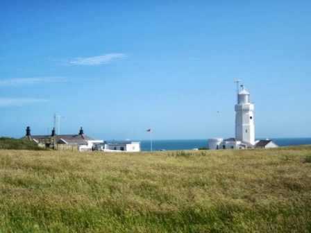
You can't go inside the lighthouse anymore, but it's still worth a walk past
|
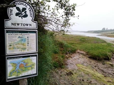
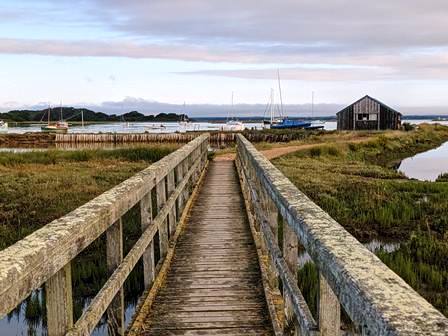
9. Newtown Creek, North East Wight (4 miles)
If you want a quiet walk away from deckchairs, ice creams and people on holiday then the North West Wight is your best bet.
I recommend Newtown Creek, which is popular with twitchers. It isn't hilly so you don't get sweeping sea views, but you do get a lot of wildlife. The National Trust has a four mile route which covers Newtown.
Alternatively, you can walk around Hamstead which is an area that most Isle of Wight residents would struggle to identify on a map. I couldn't find many 'official' walks around Hamstead but I did find a 5 mile circular route which starts from Shalfleet compiled by Wight Way on Viewranger.
A Newtown walk isn't the place for an ice cream and a cone of chips...
|
...but it's a good walk for wildlife and quiet
|
Newtown Creek is popular with birdwatchers
10. The Barnsley Trail, Seaview (3.5 miles)
The stretch of coastline between Ryde and Bembridge is very nice, but a circular walk covering the whole of that coast is a bit too far for this guide.
A shorter circular walk which covers a nice part of the East Wight is the Barnsley trail around Seaview and Nettlestone. The walk is pretty much adjacent to the St Helen's and Priory Bay walk featured earlier, so you could attempt to combine them with a bit of map studying.
About a third of the walk is near to the beach and there are a couple of options for stopping along the way.
My mother completed this walk and offered feedback that it was "nice along the coastline" but then involved a "lot of trudging round muddy fields" and "a long section walking along a road".
She did the walk on a wet day in January but I think she has a point that it isn't quite up there with most of the other walks in this top 10.
I included it because Seaview is a nice part of the Island and the walk is well mapped out. However, I would plump for the Priory Bay and St Helen's walk (#4) or Bembridge and Culver Down (#5) if you only have time for one East Wight walk.
This walk covers the beaches around Seagrove Bay...
|
...and Seaview
|
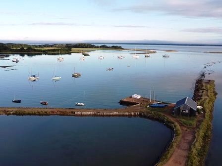
And finally...11. Medina Estuary (9 miles)
I've cranked this guide up to 11, as this walk is worth a mention even though it doesn't fit our criteria.
It heads from the west side of Cowes to the east side of Cowes by walking down one side of the River Medina and back along the other. So, you don't get to see the sea, but you are alongside water for nearly all of the walk.
It heads from the west side of Cowes to the east side of Cowes by walking down one side of the River Medina and back along the other. So, you don't get to see the sea, but you are alongside water for nearly all of the walk.
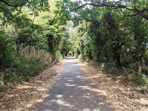
The former Newport to Cowes railway line is now part of the Medina Estuary walk
|
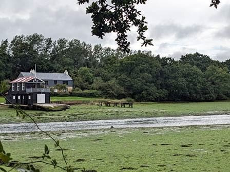
The River Medina is attractive at high tide on a sunny day. It can be a bit smelly at low tide.
|